Wednesday, April 28, 2010

Jabrin Fort / Old Tanuf - April 4, 2010

Today was a take it easy kind of day.  We started off with going to Bahla, to hopefully check out their souk for handmade goods, but we couldn't find the place.  We drove through their streets for a little tour - we saw some new building right beside the older ones, and an ancient wall (that surrounded the city) that is still standing in places throughout the town.

After exploring Bahla for a bit we went to Jabrin Fort.  This fort was first built as a palace in the 1600's, but was later converted into a fort.  It has been restored and a very neat place to visit with all the different passage ways, jails, reading rooms, date storage rooms, baths (Patrick had to figure out how the bath was working), courtyards, etc.  There were paintings on the ceilings and carvings on the wall.  A very cool place to explore with the kids.


Once done at the castle we went to the ruins of Old Tanuf.  This town had been bombed in the mid 1950's.  We did a little exploring and a little geocache hunting here in the ruins.


We made an early day of it and headed back to the hotel for an afternoon of swimming.  That evening we went into Nizwa for some exploring of the town and for supper.  We found the market where they were selling pottery, silver, old Arabian knives (the curved ones), and many more neat things.


Tuesday, April 27, 2010

Jabal Shams - April 3, 2010

Today we drove to the top of Jabal Shams (which is the highest point in Oman about 3000m).  Before we got to the point of ascending the mountain we came along a ruin.  We had a wonderful little break while we explored it.  It was quite neat.  You could make out the walls, lookout tower, and the outline of a few other buildings.  The houses look like they had been made out of mud and straw bricks that had baked in the sun.  The tower was in really good shape, we climbed to the top to see what we could see.

Once on our way again, we passed another village that had been abandoned on the ridge.  They didn't move very far, just down into the wadi, but their farms were below the old village.

At this point we started to climb and very quickly, so good thing the road was paved for 3/4's of it and in very good shape.  The view going up was absolutely amazing.  It took us quite awhile to get to the top and we thought that it would never end.  BUT we finally found the starting point of our hike.  Our destination was As Sab (an abandoned village on the mountain somewhere :) ).  We found this goat path that was our trail (it was very well marked).  The kids thought it was great fun to see who could find the next trail marker - it was great for us because it ended up being a very long hike (round trip with breaks - almost the 4 hrs).  The kids did an awesome job in the hiking and listening department, because as I said the path was a goat path!!  Take a look at the pictures, some great views.


We passed a few hikers on their way back and they told us it wasn't much father and that it was worth the hike, so we pushed onwards.  As we got closer we could make out their terrences that they used for their crops.  Then we started to see their houses, and started to wonder why on earth they had picked this spot to make their village.  The information from the hiking map said that there had been about 15 families living here at As Sab, were well protected against enemies (no kidding!) and that there was a good supply of water.  So after a long hike in we had an explore of the houses, saw a few goats and had our snack.  It was neat to be able to go into the houses and see how they would have been living there.  They were very low houses, dirt/rock floor, black up the side of the walls from the fires, the back wall was the cliff.  Again the walls were mud bricks and rocks with some wood for door frames and part of their roofs.  We didn't get over to the terrences because we knew we had to hike back and didn't want to leave it too late.  I would love to know how they farmed it though, because the terrences went right to the edge of the cliff.


The last photo, Samantha had noticed the face when we had stopped for a break on our way out.  I thought it was a pretty neat rock as well!

Once back at the hotel we flaked out and had a swim.  What a day!


Monday, April 26, 2010

Oman Trip (Abu Dhabi - Wadi Damm- Nizwa) - April 2, 2010

We decided on our spring break that we would tour the Western Hajar Mountains in Oman.  Our first day was mostly driving but we did get stopping for a geocache and a hike in Wadi Damm before going to our hotel in Nizwa.  Our first stop was at a castle for a treasure hunt.  This was a neat place, we saw our first falaj.  A falaj is their irrigation system in Oman.  It is basically a channel that has a slight slope to it and moves the water through out the farms (see picture).

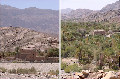
The rock folds in the mountain was very neat to see (first set of pictures below).  Again we got a little turned around (blame the navigator- too busy gawking at the site and not paying attention to the directions :) )  From the drive up the mountain a bit and once we got turned back around again we did find some cool views.  In the second set of pictures below, the left picture there was a tomb on the hill behind the new style buildings (concert) built beside the old style buildings (mud bricks).  The picture on the right looks to be a platform for either an old lookout tower or some houses.  We thought it was very Indiana Jones looking.


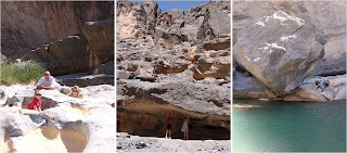
At the start of Wadi Damm we stopped for lunch and got everything ready for our hike.  We were not sure what to expect but it was pretty amazing.  First of all there was still water running in this wadi!  There were little pools throughout the rocks and they had fish in them!!  Where the fish came from who knows - it looked like the source of the water was spring based.  Also the colour of the water was a beautiful aqua blue.


It was a lovely spot to stop and explore.  As we were leaving we found some good camping spots for next fall/winter, for a return trip and further exploring.  On our way out to the main road we passed the beehive tombs, which are dated from about the third millennium BC.  We didn't go up to see them this time,  but definitely next!

You know you are loved when....

Blankie is in the wash.  Sam is patiently waiting for it! :)

Camping at the Hanging Gardens - March 26/27, 2010

We had a wonderful week-end but have come to realize that this was probably our last camp out.  It is too hot at night now for camping.  We woke up and the temperature was still reading at 34 C.  It was neat though because this was our first camp out not in sand.  Definitely cleaner from that prepective.

On our way we got a little lost but that was ok because we did a mini hike and saw some new plants.  We also got seeing the spiney tailed lizard on our detour.  Patrick took our photo for us, so thought I would share. :)

We got to the start of the hike for the bat caves and hanging gardens.  Found a primo spot for our tent so parked the truck there for the day, and then set out for our hike.  There was a treasure hidden at the bat cave but unfortunately we could not find it.  Oh well we'll just have to head out there again sometime. :)  The kids did a wonderful job on the hike.  It was hard going on some of the parts.  The hanging gardens were pretty neat to see.  The water was falling from the side of the cliff.  There was enough falling to get some heads wet to cool off.  Here are a few pics of the hike and views.


Here are a few pics of the camp site and the camels about 150m from our site.  A picture of the kids in the fire light.  Another camel shot but it is a baby and soooo cute!